Skip to content

Meridian Passages - 4. page

Meridian Passages, Volume XIII, Number 14

Central Pacific Edition


Wildlife Issue

What’s Out Here

boobies 
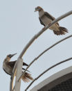
Ornithologically speaking, this place is for the birds! Boobies and terns, mainly. Boobies most likely get their name from the Spanish word bobo, meaning dunce. Boobies had the unfortunate (for them) habit of landing on sailing ships. Since they had no fear of humans they quickly became part of the evening meal.boobie

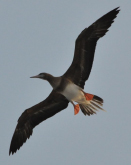
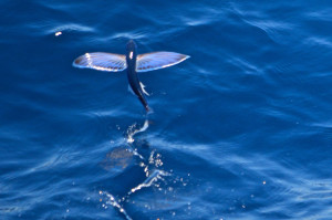
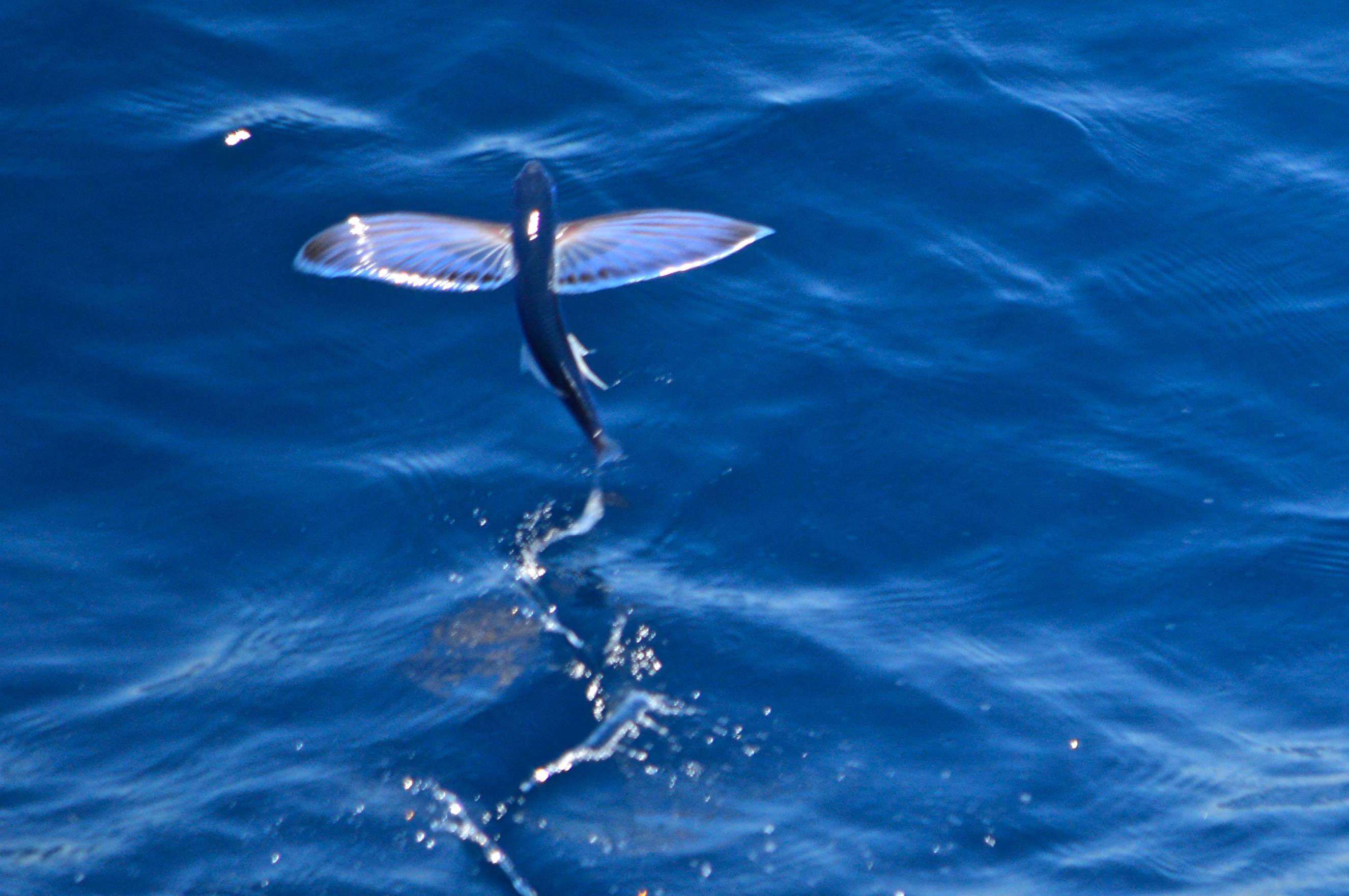
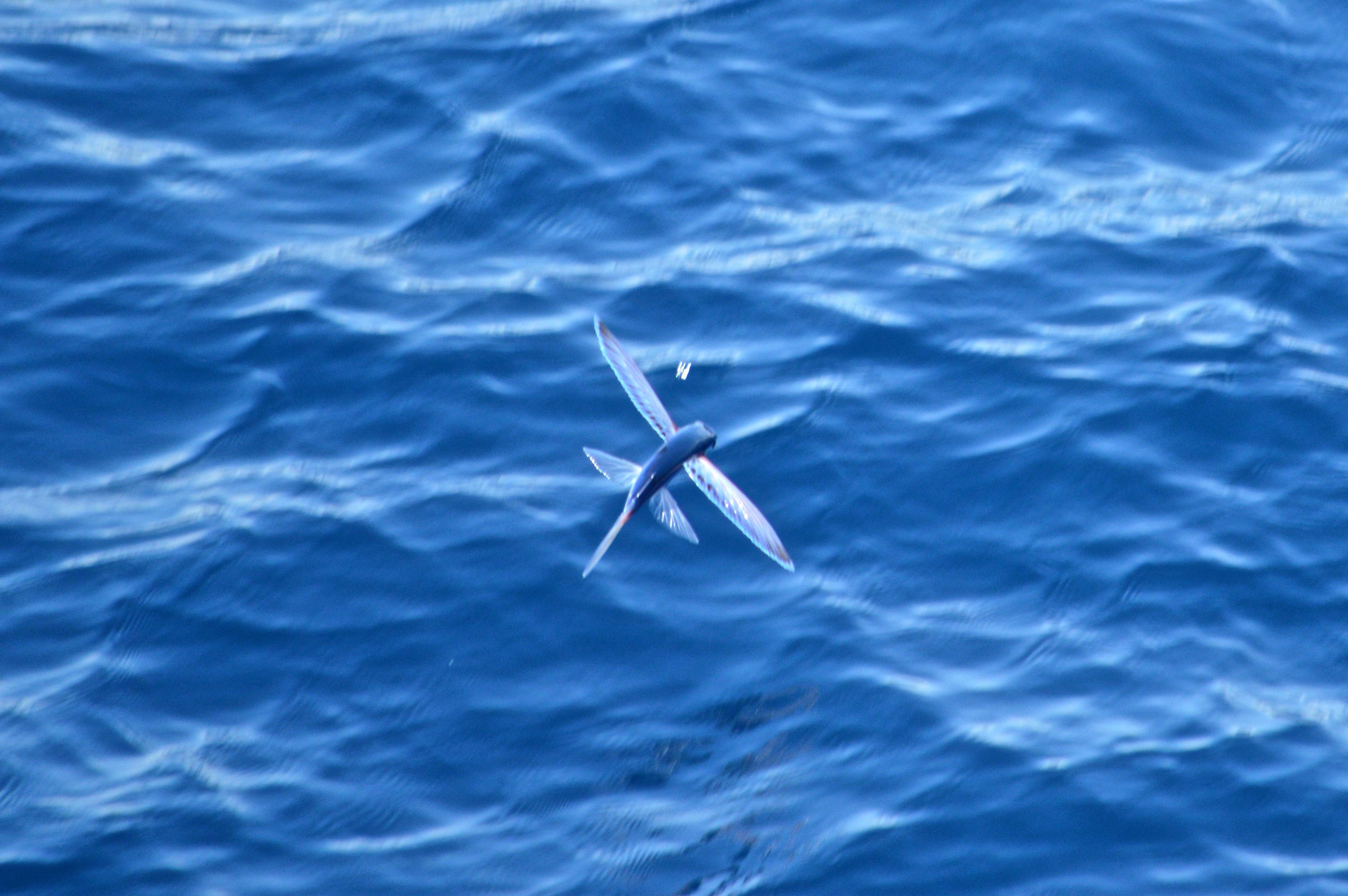
Fish are also flying around in profusion. We see them skimming the wavetops ahead of our bow. Rumor has it a wahoo was observed the other day, but we’re not telling since fishing is not allowed on Vigilance. We will tell about the huge squid that are attracted to the bright lights astern during REMUS recoveries.

DSC_0543 DSC_0546
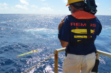
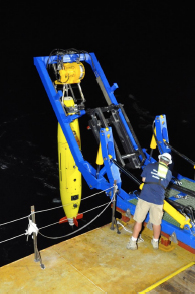
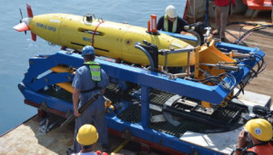
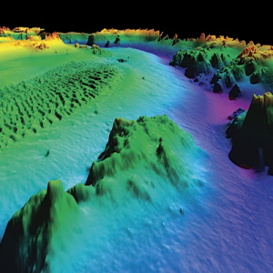
Of course the focus of our endeavors is well below the waves, and we are lucky to have a chance to see what’s down there, thanks to REMUS. Though we are mainly engaged in a sonar search for now, we did test out the camera on a sortie and managed to capture a few deep sea critters. Common on the seafloor here are acorn worms, which have no bones, no eyes and no brains with soft and gelatinous bodies. They crawl over the surface of the mud slurping the sediment and excreting a trail behind them. Yuck.

trail
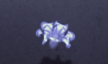
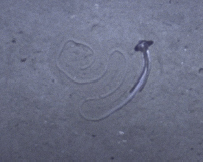
The specimen here and the other seafloor photos here were captured by REMUS at a depth of greater than 18,000 feet.

helmet-jelly
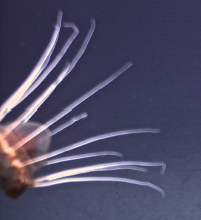
The helmet jelly is found in every ocean of the world except the Arctic, as deep as 7,000 meters (23,000 feet). They are 90% water and the rest is tissue and a gelatinous mass. They light themselves from within with bioluminescence.

Umbrella octopuses have a web of skin between the tentacles. They swim up above the ocean floor, spread their tentacles and float down collecting food looking like an opened umbrella.

octopus2 octopus
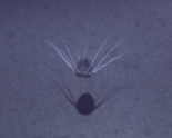
The octopus above is seen upside down, probably skittering away from the AUV. We look forward to seeing more exotic creatures of the deep the next time we turn on REMUS’s cameras.

—Sue Morris


View Full Article

Meridian Passages, Volume XIII, Number 13

Central Pacific Edition


Shooting the Stars

The Arcane Art of Celestial Navigation

navigationOn our last expedition Spence had the idea that he and I (with part-time help from many other folks) should navigate to Tarawa using only the ship’s course by compass, speed by engine setting, and the sky. No GPS or other electronic means, other than using the clock for accurate time. This is more or less equivalent to the state-ofthe- art of navigation around the time of World War II, and it’s useful as an exercise because we often deal with data from that era. It’s also fun in a nerdy sort of way.

I found that being an old-time ship’s navigator was a full-time job (and I wasn’t standing watches during the transit). A lot of it involves “shooting a fix,” using a sextant to measure the altitude (height above the horizon) of a star, sun, moon, or planet, and using tables of orbital data to calculate a ship position. The sextant works by projecting an image of a part of the sky onto another image of the horizon, with an adjustment to move the projected image in altitude. You adjust until the image of the star just touches the image of the horizon, and read the angle between the projected images off the dial. You can measure reliably down to one arc-minute (1/60th of a degree) using this instrument.

The basic principle is simple. Through astronomical observations, we know very accurately the positions of the stars, sun, moon and planets at any time. We can project the location of a particular object onto the surface of the Earth at any particular moment, known as the Geographic Position (GP). If we are at that exact position, that object would be directly overhead (that is, at an altitude of 90 degrees). If we are away from that point, the altitude will be lower, and we can use the observed altitude (measured with the sextant) to compute our distance from that GP. If we plotted the GP on a globe, and drew a circle around it with radius equal to that distance, we would be somewhere on that circle.

In practice, since we have some idea where we are in the world, we only need to draw the part of that circle that passes near our assumed location, which is a “line of position” (LOP). If we do this with three or more objects, we get several lines, all of which should pass through our position, and when we plot them, we get a position fix. Of course, there are lots of details to correct for, and the computation itself is a bit arcane, and time consuming.

Well, we found Tarawa last expedition, and heady with success, we decided to try our hand at some star fixes out here. The results were pretty good as we got an excellent fourstar fix that compared beautifully with GPS. However, it took us about 3 hours of ciphering and most of an eraser to puzzle out the answer. We’ll give ourselves a B+.

OPERATIONS SUMMARY:

Vehicle Mission 06 has REMUS on deck at 0500 for a routine turnaround service. Deck teams will be busy in the morning. REMUS will start mission 07 late in the morning. SEA School and the Daily Progress Report will be held in the afternoon.

View Full Article

Meridian Passages, Volume XIII, Number 12

Central Pacific Edition


WANTED: Wet or Dry

The Floating Dock that Eluded Capture in the Pacific for 6 Years

On March 11, 2011, an earthquake in Japan registering 9.0 on the Richter Scale shook the world. A tsunami event was generated sending walls of water over jetties and levees into seaside towns and villages along the Japanese coast. The toll of death and destruction was devastating. Officially over 15,893 persons killed, 6,152 injured and 2,567 missing. Property losses were enormous . The Japanese Ministry of Environment estimated that 4.8 million tons of tsunami debris washed into the North Pacific; 68 percent sank and 32 percent remained adrift.

The city of Misawa Japan lost four sections of its steel floating dock each 60 feet in length. Three of these sections were later found in 2012 on the shores of Hawaii, Washington and Oregon. There is one that remains undetected. It is suspected to be in the Central Pacific region in an area near the Republic of Marshall Islands. You’re right if that’s where you think we’re going next. If it is found, researchers want to tag it to that it can be tracked and eventually captured for scientific study. Alan Eustace, who will be joining us in a few days, will be bringing satellite tracking devices for this purpose. So if we encounter this runaway, we are equipped to tag it and bag it.

floaing-dockResearchers have already found about 70 species of seaweeds and 240 species of invertebrates and microorganisms living on debris, primarily along Washington and Oregon where most of the work is concentrated. Some of the species are known only from Asia, especially Japan; some naturally occur on both sides of the Pacific; some were previously introduced to North America; some are non-native to Japan; others require more study. Scientists appreciate that even one invader has the potential to cause serious environmental and economic harm. Yet history also shows that most exotics coexist with native species without becoming pests, at least in the short term. Identifying potential insurgents is the daunting challenge, given the continent’s vast, corrugated coastline and the certainty of more debris yet to come.

What is Meridian Passages?

For our search expeditions, Spence suggested that we have a daily ship’s “newspaper,” seeing it as a good way to promulgate details of the ship’s schedule (the Plan of the Day). We saw it as a fun way to get people on the ship involved with each other, to help document the experience, and provide some working material for the Education Team. Thus was born Meridian Passages, Central Pacific Edition.

Passages was a newsletter we had been publishing at Nauticos since 1997, starting back when our company operated under the name Meridian Sciences, Inc. I coined the title Meridian Passages as sort of a triple pun. Our company name was Meridian; a passage is a story, and a meridian passage is the passing of a heavenly body (like the sun, moon, or a star) across one’s meridian of longitude. Hence, the meridian passage of the sun is another name for “noon,” and it is the moment when a body is highest in the sky. The astronomical reference appealed to me, as an amateur astronomer operating a company whose specialties included the science of navigation.

So, the first edition of Volume XIII of Meridian Passages was issued on the day after we got under way. It features news of the day, the official Plan of the Day, a Spotlight on a crew member, a story or article, and a mock “Classifieds” section for fun.

Anyone can contribute, but we rely heavily on Reporter Marika for interviews, Teacher Sallie for SEA School, Photographer Sue for images, Spence for Plan of the Day, Joe for sea stories, and Bethany for layout. They and others have contributed articles and ideas for Classifieds. Of course, whatever happens out here is raw material.

Our first issue was received with raised eyebrows and puzzled looks. But after a few days, folks would come looking if we didn’t roll the presses by our self-imposed deadline.

— Editor.

View Full Article

Meridian Passages, Volume XIII, Number 10

Central Pacific Edition


Operations Begin

First Sortie Completed

mills-films-recoveryThe REMUS AUV returned to the surface on schedule, having completed its first sortie as assigned. In spite of a little more wind than predicted and some mixed seas, the recovery was flawless. Ship’s crew, the REMUS OPS team, and Nauticos personnel all worked together to get the vehicle on board smartly. Everyone not assigned a job watched from various vantage points, and Bill filmed the whole operation, of course. Data download was begun and initial review showed all sensors worked as designed. Jeff & Tom continued to review the data and Greg & his team began to ready the system for its second sortie. It will be on its way back to the bottom to continue the search in short order.

While the AUV was on the bottom, the team was busy extending the transponder pattern to cover the next areas.

Alan Eustace

Alan soars to the stratosphere

Inventor, Pilot, Explorer, Leader Alan Eustace, with a doctorate in computer science From the University of Central Florida, has led developments in pocket computing and computer architecture, and most recently retired from Google as Director of Knowledge. A pilot, skydiver, and adventurer, Alan made history in 2014 with a record breaking near-space dive from the stratosphere at 135,890 feet. Free-falling over 23 miles, he reached a speed of 821 mph (breaking the sound barrier at Mach 1.3) before slowing in the thickening atmosphere and parachuting safely to earth. His spacesuit and support equipment went on permanent exhibit at the Smithsonian Air and Space Museum on December 15, 2016. With his support of the Amelia Earhart search expedition, Alan is setting his sights on new discoveries. He will join the expedition team at sea in a few days.

Down to Rockland Way

A Cap’n Joe Sea Story

… continued from yesterday.

Down to Rockland Way In the last installment, Cap’n Joe described the events surrounding Old Joe Manley’s legendary swim. The story continues at Sangillo’s Tavern, Portland Maine, two years later: Before losing their liquor license because of too many outgoing 911 calls, Sangillo’s was the place to go to as a fisherman. Always an ol’ dory mate around to buy you a beer when you were between sites, or just someone to swap sea stories with. By this time Old Man Manley was indeed a legend in his own time for his get-aboard the Why Must He Suffer swim at the Rockland jetty – why there was even some talk of re-naming that Jetty after him, by golly! I was in Sangillo’s when Ol’ Manley came in one late morning and he had a bit of a port list aboard already. Actually, he very seldom had both oars in the water, anyway. We settled into our usual scenario: Me buying shots and beers and him drinking them.

capt-joeAfter a while Ol’ Manley went to the head to pump bilges and when he returned he sat down close abeam and said in a low voice: “Joe, I’ve got to confess.” I couldn’t imagine what in the Sam Hill he could have on mind so I didn’t say anything. Then he sprung in on me like a fouled-up tub trawl: “I was on the ol’ MustHe all the time that day back in Rockland — I can’t hardly swim a lick, much less catch a fish boat!” Well after my inevitable question of “How’d you do it?” He responded with a twinkle or maybe a tiny tear — hard to tell with Old Man Manly — in his eye:

“Ya, I did indeed go down the pier that mornin’ just as soon as you and Boy went ta the Nor’d. I put ‘er the conner right for the Hotel Bar, got myself a fifth of ol’ Doctor Green and beat feet back to the MustHe. Then I went down in the lazarette*, snubbed-up the hatch cover and proceeded to take the edge off with my Doc G figurin’ everything was hunky-dory. But then I musta fell asleep I reckon ‘cause the next I know the shaft’s a turnin’ and the rudder’s a squeakin’. So I come up otta there and you fellas wasn’t around so I took that ol’ deck hose and give myself a dousin’ then come up with that there swimmin’ yarn and went into the galley to spin it. You know the rest, now don’t ya.”

Ol’ Man Manley Doherty went to Davy Jones back in ’79 I think it was, and this is the first time this story has ever been told to my knowledge. But who knows how many times he may have “confessed” for a taste of the demon rum.

Best Reg’rds, Cap’n Joe

*The lazarette on a fish trawler is a crawl space for gear storage and the steering arms.

View Full Article

Meridian Passages, Volume XIII, Number 9

Central Pacific Edition


Opening Night

Mermaid Vigilance Arrives in Operations Area

REMUS-deployOur week-long transit has brought us to a featureless spot in the remote Pacific where the Amelia Earhart search will finally resume. Last night at around 2000 local time Mermaid Vigilance reached our first transponder deployment point, and a baseline of two beacons was dropped. We spent the next two hours surveying the
baseline, then the REMUS AUV was lowered off the stern. A smooth night launch was followed by hours of waiting as the AUV dropped to the bottom more than 18,000 feet below and began its assigned search pattern.

The REMUS OPS team was pleased with the event, and are certainly happy to be able to start collecting data. Many slow, long hours will follow as we patiently track the vehicle’s progress and await completion of the pattern.

The AUV is expected to surface late afternoon, scheduled to ensure our first recovery since sea trials a week ago will take place in daylight hours. Meanwhile, we will plan to lay and survey additional transponders and continue to add to the search pattern. As soon as REMUS returns and is safely lodged in its cradle the “pit stop” will begin. Data download will commence, batteries will be swapped, and the vehicle will be prepared for another launch.

Down to Rockland Way

A Cap’n Joe Sea Story

While a fishin’ outa Portland on the ol’ Eastern rigged draggah MustHe (not her real name, it’s just what we called her — her registered name on her State-o-Maine paper is Why Must He Suffer) we’d often steam down the coast aways to work the channel between Maine and Nova Scotia, a disputed borderline at the time but generally reliable for fair to middlin’ fishin’ on black-backed floundahs. Well we had a breakdown — not unusual on the ol’ MustHe — and was forced to veer off into Rockland t’ fetch a part and get her fixed up some.

capt-joeYoung Manley Doherty was the skipper and a very able (if somewhat excitable) fisherman. I was deckhand/cook. Enoch Johnson sailed as the engineer, of sorts, and Old Man Manley (yes, Young Manley’s pa) was aboard as the twine man. He was my mentor and a highly respected net guy up and down the whole New England coast. He was simply the best. But like a lot of fellas in the fish biz Ol’ Manley tended, on occasion, to over indulge in the demon rum and thus generally didn’t have many long term berths. So that’s how he ended up aboard the ol’ brokendown MustHe with his son. Old Man Manley called Young Manley “Boy.”

We rounded the Rockland Harbor sea jetty at about 0900 and shortly after were made all fast at Frank O’Hara’s fish dock. We all had our chores: Capt’n Manley was going to head to the Greyhound Bus Station to get the needed condenser part that his wife, Miss Betsy, was sending up from Portland (Manley had called her via the marine radio operator). Enoch was going to see if he could scrounge up some oil diapers and a few extra rags. I was going to the store to buy some more salt pork. I thought I had enough but wasn’t going to take any chances as this is used in about ninety-two and a half percent of my fixin’s. And, on very direct orders to Old Man Manley, Young Capt’n Manley said:

“Pa, you stay aboard. Work on that cod-end, it needs some seizing re-done. Don’t leave now for any reason. We’ll all be back by noon and we’re shoving off then so you stay aboard, ya hear?”

Well you can kinda guess what happened next: We all returned shortly after 1100 and Old Man Manley was not to be seen. We did a search of the MustHe, and she being just shy of seventy-two feet of wooden fish boat the search didn’t take all that long. Young Manley was up the ladder two rungs at a time and just a cursin’ a somethin’ fierce all the while as he was headin’ right two-blocked to the Hotel Bar (it opens at 0600 to accommodate the local tradesmen) to fetch his Pa. But Old Man Manley t’weren’t there neither! Back to the MustHe comes Young Manley still a cursin’ up a gale-o-breeze but not quite as loud as before having got a bit winded on the roundtrip, I suspect. Soon as Young Manley is back aboard he goes into his captain’s mode: “Fire her up, Enoch, we’re outa here, ta hell with that damn ol’ man anyway!”

Legends are born like this: We cast off from Frank’s fish dock and headed outbound past the Rockland Harbor sea jetty. Enock Willard and I were getting a mugup in the galley. Just as we rounded the jetty Old Man Manley comes in through the hatch, soaking wet, and says: “Damn! I wish you fellas had backed her off a might, I had a hell of a time catching you!” I think at the sight of the Old Man, Enoch keeled over and I was taken some hard astern myself. I finally managed to stammer: “Manley you mean to say that you jumped off that quay and swum aft’a us and hauled yerself aboard?” And Ol’ Manley smiled at us and says: “Aya, I’s here ain’t I?”

This story spread down the coast quicker than a dungeon-blue–thick o’ fog on an easterly breeze.


View Full Article

Meridian Passages, Volume XIII, Number 8

Central Pacific Edition


The Sailing Yacht Sauvage

Alan’s Ticket to the Central Pacific

sauvage-yachtOne of Mary Crowley’s (Ocean Voyages Inc. – Sausalito, CA) favorite yachts is the 60-foot Sauvage. The sailing vessel was designed for charter and expedition cruising around the world, and it will be bringing Alan Eustace out to our operating area from the island of Funafuti in a few days time. The crew of Sauvage are sailor’s sailors. They enjoy extensive global cruising to the most remote areas of the Pacific ranging from tropical lagoons to the Aleutian Islands. Mary and Ocean Voyages are proud to use this capable yacht for special expeditions and to share the joy and experience of ocean sailing.

This fine yacht was design by Jean Francois Andre and built in Brazil. Her unique centerboard design allows good access to sheltered shallow anchorages. Captain Didier Wattrelot is a fabulous sailor, born in France, with over 30 years experience as captain. In his youth, he did a single handed non-stop crossing from Polynesia to the Falkland Islands through Cape Horn aboard a 38 foot cutter. After running a variety of charter vessels and luxury yachts, he decided to build his own vessel for exploring wonderful areas of our water world, thus Sauvage was launched.

Sophie, his wife, is an equally amazing sailor. Born in France, Sophie did her first Atlantic crossing at the age of nineteen. She also worked on a variety of maxi-yachts and charter boats. She is a great first mate, hostess, cook and linguist. Sophie has gathered lots of recipes from all over the world and enjoys keeping her guests and crew well taken care of in all regards including cuisine. She also loves sports and is extremely proficient at all water activities. She can paddle canoes, windsurf, surf, kayak and is an expert at standup paddle boarding.

Chloe, their daughter, was born in 1990 and has been raised aboard Sauvage. She began helping as a stewardess, cook’s assistant, deck hand and leader for hikes and dives. She is a certified scuba diver. She is also a credentialed chef and has been deck hand, hostess and chef on luxury sailing yachts.

Nino, born in 1992, has also been raised aboard Sauvage. He is a qualified diver and he is now a certified engineer who works aboard mega yachts.

As a special occasion and opportunity to spend time together, the four family members will all be on board Sauvage during the Eustace Earhart Discovery Expedition. We look forward to seeing them when we rendezvous sometime around March 5th.

View Full Article

Meridian Passages, Volume XIII, Number 7

Central Pacific Edition


The Search

Where to Send the REMUS?

No matter what you are seeking, be it lost car keys or a Lockheed Electra, two conditions must be satisfied: you must be able to see what you are looking for, and you must look in the right place. WHOI’s REMUS 6000 has the sensors to detect the Electra, provided we send it to the right place. Today the analysis team gathered to review the body of analysis work we have conducted over the years to give a search area to the REMUS team to plan their survey.

Forty years of research by Elgen Long, pilot, aircraft investigator, and author of Amelia Earhart: Mystery Solved form the basis of solid information about Amelia’s disappearance. Aeronautical analysis of Earhart’s fuel consumption was performed by Dr. Fred Culick of Cal Tech. His analysis confirms that Amelia ran out of fuel right around the time of her last radio transmission, which is consistent with her own assessment that “gas is running low.”

A series of radio messages were received by the Coast Guard cutter Itasca in the preceding two and a half hours that tell us a lot about what Amelia was doing. Though the messages make it clear that she was desperately trying to find Howland Island and went down in the ocean nearby when her fuel ran out, the details are open to some interpretation. Because of this, the point the Electra went down is uncertain.

But the radio messages tell us more than just words. Led by Chief Radioman Leo Bellarts, the radio operators on Itasca recorded the strength of the signals they received. Engineering analysis of these radio transmissions can determine her distance from Howland Island. This work has been led by Tom Vinson and Rod Blocksome of Rockwell Collins, with the support of a cadre of radio engineers from the Collins Amateur Radio Club. The CARC team has invested over 4,000 hours into this endeavor, including a number of experiments to compute sea-wave propagation, measure performance of vintage radio equipment, and determine antenna patterns, among others.

Another clue in the analysis is visibility of the island. Howland Island is very small with little elevation, and Amelia would have been looking into the rising sun. Scientific analysis of visibility distance under the conditions of Earhart’s flight was performed at MIT Lincoln Labs among others. Elgen flew the approach himself to judge visibility under similar circumstances.

Using this information, navigation reconstruction of her final flight and statistical “renavigation” analysis has been done by Nauticos using techniques proven to be successful in other searches. This approach used a “decision tree” to explore a range of assumptions in the flight scenario. In a second technique, called a Monte Carlo analysis, Jeff Palshook of Nauticos explored four million computer-generated paths to generate a search area. A third approach developed by the CARC team did not assume any path at all, but rather considered the basic statistics of the problem and created a probability map. All three of these analyses rely on the radio range analysis performed by CARC. All are in excellent agreement.

Taking into account all of the uncertainties of the problem, the Electra should lie on the seafloor near Howland Island, somewhere in a region of about 1,800 square miles. This is a large area – half again the size of the State of Rhode Island, and around 18,000 feet deep. Over prior expeditions, almost 85% of this area has been searched.

Our meeting concluded with firm direction for the REMUS search team to pick up where we left off and complete the search for the Electra.

View Full Article

REMUS

Meridian Passages, Volume XIII, Number 6

Central Pacific Edition


REMUS 6000

WHOI’s Autonomous Deep Water Search System

REMUS
REMUS

The Woods Hole Oceanographic Institution (WHOI) REMUS 6000 Autonomous Underwater Vehicle (AUV) represents the latest in advanced deep water search technology. Unlike a towed sonar or an ROV which are tethered to a surface vessel by a long and massive cable, AUVs swim freely and can operate with great efficiency. REMUS can dive to a depth of 6,000 meters (nearly 20,000 feet) and can stay down nearly a full day before it must return to the surface for fresh batteries.

Before a dive, called a sortie, the vehicle is given a mission plan by its operators specifying a search pattern and what sensors to use. Once in the water, REMUS is on its own and must navigate, follow terrain, and avoid obstacles autonomously. If something goes wrong, it must sense the problem and take action to return safely to the surface without human intervention.

The system has proven to be highly reliable. Greg Packard, lead engineer for our Amelia Earhart search expedition, says the REMUS on our expedition has performed 223 successful dives since it was launched.

The AUV can carry a number of sensors, principle of which are a sidescan sonar that can image a wide swath of seafloor with acoustic pulses, and an electronic still camera with strobe lighting. Its sophisticated navigation system includes an inertial system that senses accelerations and an acoustic Doppler sonar that senses velocity. For precision navigation, the system operates within a network of acoustic beacons that act like an underwater GPS. Also, REMUS can communicate with the surface ship to provide tracking and status reports. Unfortunately, it is impossible to send a lot of information over acoustic links, so the operators must wait until the vehicle returns to the surface and is recovered aboard to download sonar and optical imagery for analysis.

Greg is supported by engineers Neil McPhee, Mark Dennet, and Christopher Griner who must wrangle the 12-foot long one-ton torpedo shaped vehicle out of the water using an articulated launch and recovery frame. Once on board, the system is winched into a container van where the team immediately begins preparing it for the next dive. Sonar data is downloaded; the camera is swapped with the spare (so images can be downloaded in the lab); the batteries are swapped for a freshly charged set; and a new mission sortie plan is uploaded into the vehicle’s memory. Within two hours, the system is ready to be launched on another dive to the deep.

View Full Article

Coast Guard Cutter Itasca

Meridian Passages, Volume XIII, Number 5

Central Pacific Edition


Interview: Leo Bellarts

Chief Radioman, Coast Guard Cutter Itasca

by Captain Elgen Long

Coast Guard Cutter Itasca

On April 11, 1973 I interviewed retired USCG Lt. Leo G. Bellarts who was Chief Radioman on the USCG Cutter Itasca when Amelia Earhart was flying into Howland Island from Lae, New Guinea during the morning of July 2, 1937.

I was a Petty Officer First Class Aviation Radioman in the U.S. Navy during WW II, and had learned the navy’s procedures as Bellarts had known them in July of 1937. As WWII expanded to include countries from all around the world that joined the Allied Forces the many procedures their radio operators used had to be modified and incorporated into a single unified system. Major changes had been made, “Z” signals had been eliminated and replaced with “Q” signals, the names and meanings of signal flags were changed, terminologies like “No Smoke” were forbidden, and a new phonetic alphabet had to be learned.

Leo Bellarts was able to tell me of the radio events that occurred during the morning of July 2, 1937 using the old 1937 procedures and terminology, and I was able to understand exactly what he was saying and what it meant.

KHAQQ CING ITASCA WE MUST BE ON YOU BUT CANNOT SEE U BUT GAS IS RUNNING LOW. <br/> BEEN UNABLE TO REACH YOU BY RADIO WE ARE FLYING AT 1000 FEET. <br/> KHAQQ DE NRUI R MSG R QSA 5 R A-S (500 ES S105) GA UNANSWD. <br/> KHAQQ DE NRUI R MSG R QSA 5 R A-S (3105) <br /> KHAQQ FM ITASCA UR MSG OK PLS Y WID A3 A3 / 3105 / a-s FM NRUI A-2. <br /> KHAQQCING ITASCA WE ARE CIRCLING BUT CANNOT HR U GA ON 7500 WID A ING COUN EITHER NW OR ON THE SKD TIME ON 1 HOUR (KHAQ) S5 A 3)
Excerpt from Itasca’s radio log

Bellarts told me that at 0758 Itasca Ship Time, Amelia Earhart had called the Itasca on 3105 kilocycles and said the following:

“We are circling but cannot hear you. Send a signal on 7500 kilocycles either now or on the scheduled time on half-hour.”

Bellarts added that Earhart’s signal was S-5, and was the strongest signal they ever received from her. Bellarts also said from the strength and sound of her signal he was sure she was close-aboard (very near), and no one was going to tell him, after listening to radios eight-hours a day over many years, that he couldn’t tell when a radio signal was coming from a transmitter that was very close by.

In fact he said, “I actually did go outside and stand right outside the radio shack and started listening like mad thinking well I’m going to hear a motor any second.” Earhart’s radio signals sounded to him like she was coming in “like a ton of bricks.”

Leo was so pleased that he could talk to someone who knew the procedures and understood what he was talking about, that he loaned me the original radio logs so I could make copies of them. An audio-tape of the interview with Leo Bellarts and copies of the original radio logs are in the Amelia Earhart Archives.

View Full Edition