Central Pacific Edition
In the Zone
Elgen Tells More Than You Wanted to Know About Time
There is a direct but unconnected relationship between the measurement of time and the world in which we live. Daily time is tied to the movement of the sun, but time standards are a human construct. Believe it or not, the United States did not have official universally accepted time zones until Congress passed The Standard Time Act of March 19, 1918, and that was just 9 years before I was born. Yikes! I’m nearly as old as our times zones in the United States!
In the centuries when the world was believed to be flat, and it was thought that there was nothing but water to the west between Europe and China there was little transportation or commerce between the few people then on earth, and little need or desire to keep track of time. The sun came up, and the sun went down, and for those living so went the days of their lives.
Marco Polo, Christopher Columbus, Magellan, and several other adventurers discovered there was a very large world out there that could supply things that would add wealth to their countries’ coffers. This immediately stimulated transportation to acquire the wealth overseas that could be had for the taking, and ships in the oceans needed a standard means of telling time to be able to navigate precisely across those oceans to access that wealth.
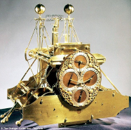
Greenwich Mean Time (GMT) was established when the London Royal Observatory was built in 1675. I t provided a standard time connected to the stars that ships needed so they could navigate across the oceans to provide the means of commerce. That spawned the need for clocks that were able to keep accurate time aboard ships in order to calculate longitude. The first useful marine chronometer was invented by John Harrison in 1761. His story is told the the book Longitude by Dava Sobel, a classic tale of the founding of an accurate chronometer for ships. Another excellent (and more technically accurate) source i s Plotting the Globe by Avraham Ariel.
Except for ships at sea, there was little need for a standard time zone as most people in the United States and around the world were happier to have their time controlled locally. Communities of any size had the their own observatories that would measure exactly when the sun was highest and everyone would then set their clocks to 12 o’clock noon. Locally it worked great and everybody was quite content with it.
Even at seaports around the world the local observatory’s time worked very well for the ships in the harbor. Before ships carried radios, most major ports in the world had a ball like the one in Times Square (used on New Years Eve) that could be seen from almost anywhere in the harbor. At noon every day the harbor city’s local observatory would countdown to the handler of the ball so that it would reach the bottom at exactly 12 o’clock noon. If a ship’s navigator knew when the local time was exactly high-noon he would know what his longitude was, and vice-versa.
Decades before the U.S. Congress ever assigned the official time zones for our country the railroads had already found out that each city having its own special time was unworkable. So in the latter part of the 19th century the railroads divided the country into railroad time zones with most of the borders passing through the railway stations of major cities.
In 1883 on November 18 each railroad station clock was reset as standard time noon was reached in each time zone. This became known as “the day of two noons.” Detroit was the last major city to leave its local time zone. On the boundary between zones, the city adopted Central Time in 1900 and finally settled on Eastern Time with the rest of the state in 1916, two years before the congressional act that ended the confusion for good.
During the early part of the 20th century various countries accepted the GMT system with (usually) regional even-hour offsets, though there are some exceptions that use a half-hour offset and even a few locales with quarter-hour offsets. Nepal was the country last to join in 1986 with an offset of 5 hours and 45 minutes.
I have not mentioned the use of UTC (Coordinated Universal Time) which is “Z” or Zulu time, and will save that topic for the next time we meet.
— Elgen Long
REMUS Image of the Day