Skip to content

Meridian Passages - 2. page

Meridian Passages, Volume XIII, Number 34

Central Pacific Edition


Re-Supply Mission

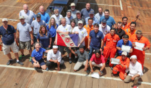
Vigilance Hooks Up with S/V Machias

Being an oceanographer is not quite the same as being a professional sailor. Oceanographers have the best of two worlds – both the sea and the land. Yet many of them, like many sailors, find it extraordinarily satisfying to be far from the nearest coast…”

— Roger Revelle (1909-1991)

Yesterday we welcomed the good ship S/V Machias built in the State of Maine and operated from Honolulu. We learned that skipper and owner, Cap’n Bill Austin, is a well known representative of both the sea and land worlds and precisely the kind of person we needed for a mission to our remote location.

His crew of three are seasoned seamen who are fiercely loyal and confident in their captain. All of which builds our confidence in the intrepid team.

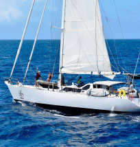
Machias is an eighty-two foot Maine-built steel-hull, stay sail schooner, registered as a freight carrier and operating out of Honolulu. With a long history of educational work for the University of Hawaii and the Honolulu public schools in past decades, it has been part of the community and is still engaged in whatever venture puts her to sea.

According to Mary Crowley, the word “Machias” roughly translates in the Native American Passamaquoddy tribe language as “little bird on big water,” a reference to the Machias River in Maine. Machias is known as the site of the second naval battle in the American Revolution. In his History of the Navy of the United States of America, none other than James Fenimore Cooper dubbed this engagement “the Lexington of the Seas.” The battle, which occurred in June 1775 at Machiasport, began after townspeople refused to provide the British with lumber for barracks. This led to the capture of the armed schooner HMS Margaretta by settlers under Captain Jeremiah O’Brien and Capt. Benjamin Foster.

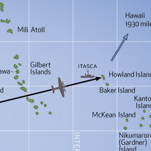
Aboard Machias was precious cargo important to our mission, specifically ten glass spheres used as deep sea floats for transponders, and two replacement transponders used for underwater navigation. There were also some treats for the teams living and working aboard the Mermaid Vigilance: chocolate, macadamia nuts, and a few other delights.

The re-supply mission was organized in some haste on March 6th as a rash of float failures (a very unusual occurrence) threatened to stall our expedition before it had hardly begun. With a normal inventory of eight pairs plus spares, the REMUS team was down to five operating units early on and four before the resupply arrived. Fortunately, the team managed to juggle the available units with little loss of survey time. Offered a bonus for quick response, Cap’n Austin organized a crew and took on supplies for a three-week sea voyage in just a few days. His cargo arrived from Massachusetts and was carefully packed on board with help from the University of Hawaii Marine Center. Machias got underway on March 12th for a 10-day transit. Mary Crowley of Ocean Voyages helped setup the charter.

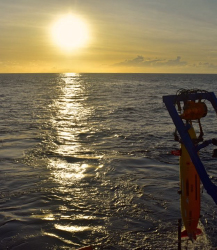
Cap’n Joe organized the deck crew and rehearsed the event the day before. It was a busy morning as Machias came in sight around 0800, just as REMUS OPS was launching the AUV.

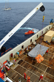
Cap’n Noe took charge of the ship’s launch, known as the FRC (Fast Response Craft) and fetched the cargo in three trips back to Vigilance, where it was hoisted aboard by crane. The operation went very smoothly and soon Machias reversed course and headed back home.

Our own Cap’n Joe has small acquaintance with land, but while at sea he appears to have no aversion to treats.

— Charlotte Vick

And thanks to Charlotte for a tremendous job getting this important mission off the ground in such short order!

— ed.

View Full Article

Meridian Passages, Volume XIII, Number 33

Central Pacific Edition


A Sea Tale

With Pigs!

Dear Sir: It is with regret and haste that I write this letter to you; regret that such a small misunderstanding could lead to the following circumstances, and haste in order that you will get this report before you form your own preconceived opinions from reports in the World Press, for I am sure that they will tend to overdramatize the affair.

We had just picked up the pilot, and the apprentice had returned from changing the “G“ flag for the “H,“ and being his first trip was having difficulty in rolling the “G” flag up. I therefore proceeded to show him how, coming to the last part I told him to “let go.” The lad, although willing, is not too bright, necessitating my having to repeat the order in a sharper tone.

At this moment the Chief Officer appeared from the chart room, having been plotting the vessel’s progress, and thinking that it was the anchors that were being referred to, repeated the “let go” to the Third Officer on the forecastle. The port anchor, having been cleared away, but not walked out, was promptly let go. The effect of letting the anchor drop from the pipe while the vessel was proceeding at full harbour speed proved too much for the windlass brake, and the entire length of the port cable was pulled out “by the roots.” I fear that the damage to the chain locker may be extensive. The braking effect of the port anchor naturally caused the vessel to sheer in that direction, right towards the swing bridge that spans a tributary to the river up which we were proceeding.

The swing bridge operator showed great presence of mind by opening the bridge for my vessel. Unfortunately he did not think to stop the vehicular traffic. The result being that the bridge partly opened and deposited a Volkswagon, two cyclists and a cattle truck on the foredeck. My ship’s company are at present rounding up the contents of the latter, which from the noise I would say were pigs. In his efforts to stop the progress of the vessel the Third Officer dropped the starboard anchor, too late to be of practical use for it fell on the swing bridge operator’s control cabin.

After the port anchor was let go and the vessel started to sheer I gave a double ring Full Astern on the Engine Room Telegraph, and personally rang the Engine Room to order maximum astern revolutions. I was informed that the temperature was 83 degrees, and was asked if there was a movie tonight. My reply would not add constructively to this report.

Up to now I have confined my report to the activities at the forward end of my vessel. Down aft they were having their own problems. At the moment the port anchor was let go, the Second Officer was supervising the making fast of the aft tug, and was lowering the ship’s towing spring down into the tug.

The sudden braking effect of the port anchor caused the tug to “run in under” the stern of my vessel, just at the moment when the propeller was answering my double ring Full Astern. The prompt action of the Second Officer in securing the shipboard end of the towing spring delayed the sinking of the tug by some minutes thereby allowing the safe abandoning of that vessel.

It is strange, but at the very same moment of letting go the port anchor there was a power cut ashore. The fact that we were passing over a cable area at that time may suggest that we may have touched something on the river bed. It is perhaps lucky that the high tension cables brought down by the foremast were not live, but owing to the shore blackout it is impossible to say where the pylon fell.

It never fails to amaze me, the actions and behavior of foreigners during moments of minor crisis. The pilot for instance, is at this moment huddled in the corner of my day cabin, alternately crooning to himself and crying after having consumed a bottle of gin in a time that is worthy of inclusion in the Guinness Book of Records. The tug captain on the other hand reacted violently and had to forcibly be restrained by the Steward, who has him handcuffed in the ship’s hospital while he is telling me to do impossible things with my ship and my person. I enclose the names and addresses of the drivers, and insurance companies of the vehicles on my foredeck, which the Third Officer collected after his somewhat hurried evacuation of the forecastle. These particulars will enable you to claim back the damage that they did to the railings of number one hold. I am closing this preliminary report for I am finding it difficult to concentrate with the sound of police sirens and the flashing lights. It is sad to think that had the apprentice realized that there is no need to fly pilot flags after dark, none of this would have happened.

The End

I first saw this story in 1996, credited to Captain Neil C. Norton, former Queen’s Harbour Master, Esquimalt, British Columbia, Canada. If it isn’t true, it should be!

— ed.

View Full Version

STS-133 International_Space Station after undocking

Meridian Passages, Volume XIII, Number 32

Earth Orbit Edition


ISS Issue

From Sea to Space

Astronaut Shane Kimbrough
Cosmonaut Sergei Ryzhikov

November Alpha One Sierra Sierra, this is November Yankee Zero Victor, Maritime Mobile, copy?…”

“… November Alpha One Sierra Sierra heard you loud and clear.”

Station Commander Shane Kimbrough’s (Radio call sign NA1SS) voice was met with clapping and cheers When Tom Vinson (NY0V) made contact. The crew in the International Space Station is extremely busy and a few previous attempts to chat didn’t pan out. So the crowd gathered on the bridge of the Mermaid Vigilance knew this talk was special.

Sallie Smith jumped on the microphone first and asked if he had a message for the kids and educators following along on our expedition. He said he has a soft spot in his heart for educators and his message for the kids was, “You have to work hard. Things don’t come easy. Things like this require a lot of work, as well as anything that’s worthwhile in life. So study hard, work your tail off. Find something you are passionate about and then get after it and you will be amazed at what you can accomplish.” Cap’n Joe was next and he told Kimbrough it was an honor to be speaking with the commander. They chatted about how the ISS crew will be heading home in three weeks on April 10th to complete their six-month mission. Joe asked if they talk Earth politics with the cosmonauts. It turns out that part is similar to ship etiquette; the diverse group stays away from politics and just keeps things business and pleasure. Marika then asked about his favorite thing to do in the unique environment. Kimbrough said his favorite thing is to look out the window back at our beautiful planet.

Next Oleks said a quick few words to Russian Cosmonaut Sergey Ryzhikov wishing him a successful and safe stay and return from space. Then Sergiy got to speak with Sergey! Our ship’s ETO and the cosmonaut chatted in Russian about how little free time there is up there and the beauty of life out the window. I think our Sergiy wins the award for the biggest smile through the event. Tom explained what we are up to out here looking for the Electra and Kimbrough asked how the search was going. Tom said all was well and mentioned we were using a REMUS AUV from WHOI searching at 5,500 meters depth.

The very exciting exchange ended with an agreement to try to get astronaut Peggy Whitson on the line next time. “Chat again on Sunday. NA1SS, out”

— Marika Lorraine

STS-133 International_Space Station after undocking
FUN FACT: The astronauts on ISS were the closest humans to Mermaid Vigilance when it passed overhead yesterday!

View Full Article

Meridian Passages, Volume XIII, Number 31

Central Pacific Edition


Spring on the Mermaid

Declination: Zero!

Photo: Marika Loraine

While much of the United States digs out from under a blanket of late winter snow, spring has sprung on the Mermaid. Under azure blue skies filled with puffy clouds and gentle east winds, we survey our way into the new season.

The vernal equinox (vernal meaning “spring” and equinox meaning “equal nights”) is when daytime is exactly as long as the night. There is another one in the fall. If we’re still out here at that time, I’ll be sure to write to you again. This is the one day of the year in which the sun makes a northerly crossing of the Equator. This means that for one instant, the sun will be directly overhead on the Equator at a predicted time and location. Its declination (angular distance from the celestial equator) will be zero degrees. Let’s look into that. The resource needed is a book cal led the Nautical Almanac. It’s a required publication carried on all commercial vessels. Published by a number of sources, it amounts to a directory of the stars, sun, moon and planets in our solar system and their location addresses at any point in time and for any location on earth during the year. Navigators use this information when they make celestial observations of these bodies. Certainly Fred Noonan used it when he and Amelia Earhart navigated their way around the world.

For the sun at equinox, we know that its location is on the Equator, but when and where on the Equator? We have to go to the Nautical Almanac.

Open the book to any page. On the right hand page is a column for the sun. The information is tabulated for each day and hour of the year. The equivalent of latitude for the sun is called declination. Declination changes with time due to the earth’s orbit around the sun and the spinning on its axis. Go to the pages for the early part of the year. The sun’s declination is South in January, February and March. But it is getting less south each day. So we look for the day of the crossing, and it occurs in March. Now observe that declination changes from south to north on March 20th. It occurs exactly between the hours of 10 and 11 Greenwich Mean Time. So we can see that at 1030 GMT on March 20 the equinox occurs. In local time on the Mermaid (-11), that’s March 19th at 2330, just before midnight tonight.

But wait there’s more. What about where it occurs? It is only on the Equator for an instant as it moves northward. Back to the Nautical Almanac, back to the page for March 20th, back to the column for the sun, back to the hours 10 and 11. There is an equivalent for the sun’s longitude call GHA, Greenwich Hour Angle. This is the angle starting at Greenwich that sweeps westward, counterclockwise looking down from the North Pole. GHA is tabulated for each hour. We can see at 10 GMT, GHA is 328 degrees 8.8 minutes, 328° 08.8’. At 11 GMT, GHA has increased to 343° 09.0’. By simple mathematical interpolation, the GHA for 1030 would be exactly in the middle, 335° 38.9’. A GHA angle of this amount is the same as measuring longitude east or west. In this case, we would measure it to the west of Greenwich 24° 21.1’W longitude. Where’s that?

This happens to be a point on the Equator located in the middle of the Atlantic Ocean. What is near it? It’s about equal distant from two prominent points of land: the eastern elbow of Brazil, close to Natal, and the western elbow of Africa, close to Dakar. Does that ring a bell? Those were the starting and ending points for Amelia Earhart’s crossing of the Atlantic on her Around the World Flight attempt. Small world, isn’t it?

— Spence King

View Full Article

Azimuthal Map The Earth from 0°30’N, 177°W courtesy Tom (NS6T)

Meridian Passages, Volume XIII, Number 30

Central Pacific Edition


The World from Here

A Milestone from the Radio Guys

Last night [written March 15] I finally worked into Europe. [That means made contact with a fellow ham, in amateur radio lingo – ed.] This finishes up a “Worked all Continents” from the good ship Mermaid Vigilance. One would think that Antarctica might be the last one in the bag. Not this time. I had found RI1ANC at the Russian Antarctic station earlier in our expedition. Europe, however is a difficult one from here in the Central Pacific. The reason for this is that EU is due north on the great circle path. That of course takes your signal up and over the North Pole where there is a convergence of our earth’s magnetic fields. These, plus any Aurora Borealis will significantly disturb the electromagnetic waves of our radio signal. Signals will often be watery or hollow sounding when this occurs.

I finally bagged HA4FF in Hungary on our “greyline” or “terminator” path. Greyline is when the sun is either rising or setting, that is, the sky is not full daylight and not fully night. At these two times per day there are opportunities for having better signals along these paths. This phenomena is caused by the very rapid ionization or de-ionization of the ionosphere. When the greyline for two stations is in good alignment, there is an opportunity to have communications between the two stations which might not occur otherwise. On the lower frequency bands these openings may be only seconds to maybe 15 minutes long! Yes, talk fast!

Azimuthal Map The Earth from 0°30’N, 177°W courtesy Tom (NS6T)
Azimuthal Map
The Earth from 0°30’N, 177°W courtesy Tom (NS6T)

Another milestone we reached with this station is 25 countries. In our amateur radio world some of these “countries” are entities that belong to other countries, but are separated by at least 250 km. There are other rules established for what determines an entity that I won’t bore you with here. So Hawaii and Alaska are counted as separate “countries.” Another example is the far reaches of the island nation of Kiribati. The country’s islands stretch over 2,000 miles. There are West, Central, and Eastern Kiribati entities that are surrounding us here near Howland Island. These were the former British Phoenix, Caroline, and Line island groups. Each group counts as a separate entity.

Some of the more exotic of the countries contacted are: Macao, Ghana, Namibia, Pitcairn Island (of Mutiny on the Bounty fame), Austral Islands, Tonga, Temotu province, San Andres Island, and Nepal. You may wish to google these locations. Radio is good for your geography! — Tom Vinson (NY0V)

Majuro

At the end of our expedition, we are planning to dock in Majuro, the capital and and largest city of the Republic of the Marshall Islands. Though it spans an area of 114 square miles, most of that is lagoon, and the land area of the 64 islands in the atoll amounts of a mere 3.7 square miles! The highest elevation on the island is a scant 10 feet above sea level. The Marshall group is comprised of some 34 coral islands or atolls lying north of Kiribati and Micronesia and extending to the west as far as the Marianas.

Most of the population of close to 30,000 live on the eastern end of the chain, where most of the land area lies. The airport is on a narrow strip to the south. The economy depends on the operation of the U.S. missile testing rang on Kwajalein and some tourism. Most of the outer island people live on subsistence farming and fishing, and the production of copra.

The island has seem human habitation for 2,000 years or more. In the modern era, the atoll along with the rest of the Marshall Islands was claimed by Germany, but was captured and occupied by the Japanese during Word War I. In January, 1944 American troops invaded the island, finding it undefended. It was used as a forward base of operations for the U.S. Navy during the rest of the war. The territory was retained by the United States until it was granted independence in 1986.

View Full Article

Conductivity- Temperature-Depth Graph

Meridian Passages, Volume XIII, Number 29

Central Pacific Edition


Sound Advice

Is There an Echo in Here?

CTD (Conductivity-Temperature-Depth)

The amazing images we are seeing from the ocean floor are derived from echoes of sound bouncing off the undersea terrain and returning to our sonar. Making sense of this information depends critically on the speed of sound in the water. This varies quite a bit depending on conditions, so the REMUS is equipped with a CTD (Conductivity- Temperature-Depth) sensor that is used to calculate sound speed. Although we are only interested in the speed near the bottom, the sensor operates as soon as it hits the water and so will give us measurements all the way down. We took the opportunity to look at this “sound velocity profile” to see what it might tell us.

Under standard lab conditions, sound travels about 1,560 meters per second in seawater (much faster than the 340 meters per second in air). That’s just about a mile per second. But it varies quite a bit as the elasticity* of the water changes in response to changes in temperature, depth, and to a lesser extent, salinity. The biggest effect is temperature, which has a very complicated influence on elasticity due the the unique structure of the H2O molecule. With most fluids, sound speed decreases with temperature, but with water it actually increases by about 3 m/sec for every 1 °C increase. Sound speed also increases with depth (because the pressure increases and changes elasticity) by about 1.7 m/sec for every 100 m change in depth.

Conductivity-Temperature-Depth Graph
The measured temperature and calculated sound velocity changes as the REMUS descended to the depths on one of its missions.

The plot on this page shows how the measured temperature and calculated sound velocity changed as the REMUS descended to the depths on one of its missions. This is a classic profile. The temperature at the surface was a balmy 27.5°C (82°F), but dropped sharply to about 5°C just 1,000 m down. By the time REMUS reached 5,500 m it was a bone chilling 1.3°C, just above freezing. Influenced by the temperature, the sound velocity dropped sharply down to the first 1,000 m. At that point, the relentless increase in pressure with depth took over as the temperature stabilized, and the sound velocity rose back to and above its surface value. (Salinity effects were also calculated but were small.) The sound speed changed by more than 4% over this range.

Besides its effect on the sidescan sonar, changes in sound velocity cause the paths sounds travel to vary, much like a lens alters the path of light. As a wave of sound passes through the water, some parts of the wavefront move faster than others causing the sound to bend away from areas of higher velocity. A particular consequence of this can be seen if we look at the shallower (first 200 m depth) of this plot. Mixing of surface water warmed during the day to deeper regions, and subsequent cooling at night, will typically cause an “isothermal” (constant temperature) layer near the surface, or even a temperature “inversion,” where it gets warmer as one goes deeper, to a point. This can occur in tropical waters thanks to intense solar heating and strong wave action. Below that layer, the temperature will drop as described earlier. This thermal layer can cause large variations in sound wave propagation. Submariners take advantage of this as a submarine lurking just below the layer can be “hidden” from sonars listening at the surface, since its sounds will bend to greater depths. On the other hand, a ship on the surface may escape the attention of the submarine below the layer since its sounds may remain confined to shallower regions. In some cases, the sound can be trapped in a “surface duct” and propagate for many miles horizontally, while making not a whisper below the layer.

View Full Article


This dramatic sidescan image mosaic shows an underwater landslide with material flowing from higher elevations on the upper left to flat terrain below. The feature is about a mile across and lies at a depth of about 18,000 feet.

Meridian Passages, Volume XIII, Number 28

Central Pacific Edition


In the Zone

Elgen Tells More Than You Wanted to Know About Time

Harrison’s First Marine Clock, H1, 1735

There is a direct but unconnected relationship between the measurement of time and the world in which we live. Daily time is tied to the movement of the sun, but time standards are a human construct. Believe it or not, the United States did not have official universally accepted time zones until Congress passed The Standard Time Act of March 19, 1918, and that was just 9 years before I was born. Yikes! I’m nearly as old as our times zones in the United States!

In the centuries when the world was believed to be flat, and it was thought that there was nothing but water to the west between Europe and China there was little transportation or commerce between the few people then on earth, and little need or desire to keep track of time. The sun came up, and the sun went down, and for those living so went the days of their lives.

Marco Polo, Christopher Columbus, Magellan, and several other adventurers discovered there was a very large world out there that could supply things that would add wealth to their countries’ coffers. This immediately stimulated transportation to acquire the wealth overseas that could be had for the taking, and ships in the oceans needed a standard means of telling time to be able to navigate precisely across those oceans to access that wealth.

Greenwich Mean Time (GMT) was established when the London Royal Observatory was built in 1675. I t provided a standard time connected to the stars that ships needed so they could navigate across the oceans to provide the means of commerce. That spawned the need for clocks that were able to keep accurate time aboard ships in order to calculate longitude. The first useful marine chronometer was invented by John Harrison in 1761. His story is told the the book Longitude by Dava Sobel, a classic tale of the founding of an accurate chronometer for ships. Another excellent (and more technically accurate) source i s Plotting the Globe by Avraham Ariel.

Except for ships at sea, there was little need for a standard time zone as most people in the United States and around the world were happier to have their time controlled locally. Communities of any size had the their own observatories that would measure exactly when the sun was highest and everyone would then set their clocks to 12 o’clock noon. Locally it worked great and everybody was quite content with it.

Even at seaports around the world the local observatory’s time worked very well for the ships in the harbor. Before ships carried radios, most major ports in the world had a ball like the one in Times Square (used on New Years Eve) that could be seen from almost anywhere in the harbor. At noon every day the harbor city’s local observatory would countdown to the handler of the ball so that it would reach the bottom at exactly 12 o’clock noon. If a ship’s navigator knew when the local time was exactly high-noon he would know what his longitude was, and vice-versa.

Decades before the U.S. Congress ever assigned the official time zones for our country the railroads had already found out that each city having its own special time was unworkable. So in the latter part of the 19th century the railroads divided the country into railroad time zones with most of the borders passing through the railway stations of major cities.

In 1883 on November 18 each railroad station clock was reset as standard time noon was reached in each time zone. This became known as “the day of two noons.” Detroit was the last major city to leave its local time zone. On the boundary between zones, the city adopted Central Time in 1900 and finally settled on Eastern Time with the rest of the state in 1916, two years before the congressional act that ended the confusion for good.

During the early part of the 20th century various countries accepted the GMT system with (usually) regional even-hour offsets, though there are some exceptions that use a half-hour offset and even a few locales with quarter-hour offsets. Nepal was the country last to join in 1986 with an offset of 5 hours and 45 minutes.

I have not mentioned the use of UTC (Coordinated Universal Time) which is “Z” or Zulu time, and will save that topic for the next time we meet.

— Elgen Long

REMUS Image of the Day

This dramatic sidescan image mosaic shows an underwater landslide with material flowing from higher elevations on the upper left to flat terrain below. The feature is about a mile across and lies at a depth of about 18,000 feet.


View Full Article

EEDE Team

Meridian Passages, Volume XIII, Number 27

Central Pacific Edition


The Team

Cast & Crew

EEDE Team
Note: Photographer Bill and two members of the
crew not pictured – someone had to steer the ship!

The Meridian Passages staff have fielded requests for a list of personnel aboard. Included here are the 36 folks sailing on Mermaid (counting Alan who was with us March 4-14) and the Nauticos team ashore providing regular & critical support. Of course, there are also folks at WHOI, MMA Offshore, U. of Hawaii, ship agents, crews of SauVage & Machias, CARC Cedar Rapids, NOAA, NASA, and helpers scattered around the hemisphere, not to mention our friends & families at home who are missing us and helping in many ways.

Roles listed here are primary duties, though everyone pitches in to get the job done.

Alan Eustace – Expedition Leader

Dave Jourdan – Coordinator & Publisher

Elgen Long – Advisor


Operations

Spence King – Operations Manager

Tom Dettweiler – Technical Manager

Greg Packard – AUV Team Leader

Jeff Morris – Chief Sonar Analyst

Joe Litchfield – Ship liaison & Seadog

Christopher Griner – AUV Operator

Neil McPhee – AUV Operator

Mark Dennett – AUV Operator


Radio Communications

Tom Vinson NYØV – Comms

Rod Blocksome KØDAS – Comms Media

Bill Mills – Director of Photography

Bryan McCoy KAØYSQ – MacGyver


Education & Outreach

Sallie Smith – Teacher

Marika Lorraine – Journalist

Sue Morris – Imagery & Ops Support


At-Sea Support

Jon Thompson – Exhibitionist

Pam Geddis – Doctor & Impersonator


Ashore Support

Charlotte Vick – Ashore Logistics & PR

Louise Mnich – Negotiator & Legal-beagle

David Kling – Master of Coin

Jenne James – Ashore Coordinator

Bethany Lacroix – Website & Comms


Mermaid Vigilance Crew

Noe Flores Armenta – Master

Lania Kurniauan – Chief Officer

Rifky Harimadya – 2nd Officer

Oleksandr Baybak – Chief Engineer

Andriyanto – 1st Engineer

Samsul Bachri Leorima – 2nd Eng.

Sergiy Stepanov – ETO

Iksan Natta – Bosun

Abdullah Mahmud – AB

Ahmad Derita – AB

Burhan Andi – AB

Kasmawir – Oiler

Kasman Sonne – Oiler

Jan Pieter – Chief Cook

Mardan Andi Kanna – 2nd Cook

Susanto Doni – Steward


Message from SauVage

[In reply to our farewell message sent yesterday…]

Thanks for those sweet words. We never thought that our old sheet padding fabric would be so much appreciated! Enjoy the wines. We wish you the best for the research and we feel honored to have been part of this exciting mission. We read the books! So interesting! And meeting Alan is great. We are sailing in optimal conditions, no swell, good beam winds, smooth glide. Still 480 NM to go.

Cheers, Sophie, Didier, Cloe, Nino, Alan

The Fate of the Itasca

We know that the US Coast Guard procured ten cutters of the Lake class commissioned starting in 1928. Each carried the name of a lake in the United States. My research shows the US Government transferred the cutters to Great Britain in 1941 under the lend-lease program. The British rechristened the ships with new names and refitted the ships for war.

The Pontchartrain (HMS Hartland) and Mendota (HMS Walney) were both sunk by gun fire on Nov. 8, 1942 off the coast of Oran, North Africa and the Sebago (HMS Culver) was torpedoed and sunk by the German sub U-105 on Jan 31, 1942. The remaining seven former Lake class cutters (Chelan, Tahoe, Champlain, Itasca, Saranac, Shoshone, and Cayuga) were returned to the United States after the war – probably nearly worn out. The trail of Itasca (HMS Gorleston) ends in 1950 with it being sold for scrap.

My family once owned a 1950 Ford sedan. Perhaps it contained some of the Itasca’s steel?

— Rod Blocksome

View Full Article

Meridian Passages, Volume XIII, Number 26

Central Pacific Edition


Farewell

Alan Begins Journey Back to Civilization

We were sorry to see Alan depart today on the sailing vessel SauVage, bound for Funafuti, then Fiji, then the Mainland and eventually to Lancaster, PA. It will take him about five sailing days to cover the over 600 nautical miles to the Funafuti atoll south of here, and considerably less time to make it the rest of the way to Pennsylvania.

Unfortunately, owning to timing and short scheduling window of this expedition, Alan was unable to spend the entire search mission on board. However, the ten days he spent with us were a great experience for all. He was able to immerse himself in our operations, catch up with details of the analysis work that underpins our search having all the experts at hand, and dive into the technology of REMUS and our sonar analysis tools. In a few short days he became an integral part of the team and said he enjoyed the camaraderie. Before he left, he thanked the Captain and crew for their hospitality and left us with some words of support and encouragement.

Spence reported feeling separation anxiety in response to losing a shipmate. Doc Pam examined him, expressed only mild concern, and prescribed a dose of Oreos. Pam herself was seen trying to climb over the rail as the sailboat departed, but was restrained by Bryan who slapped a running taut line hitch around her wrist.

The crew of SauVage took on a load of fuel from us, and returned the favor with a swag bag of goodies. Included was a lube oil filter for the Engineer, a SauVage t-shirt, some fancy scarves, a postcard, and three bottles of spirits. Doc Pam immediately took custody of the alcohol, and said she would inventory it in her cabin. She expressed “concern” that it be administered properly. (Did we mention this is a “dry” ship?) After departure, we sent the following message to the Captain and crew of SauVage:

Thank you for your kind gift of nice wines, liqueur and colorful fabrics. These things thrilled our team. Our captain was most pleased at the sight of the fuel filters; our ladies were most excited for the chance to improve fashion around here; and we all are looking wistfully at the wines and liqueur. The vessel owners did not think to provide us any cork pullers. But we have engineers, so don’t worry about us.

We hope you get off to a good start and have a safe trip to Funafuti.

For Alan:

From all of us here we join together to say thank you for sharing time with us and showing your support in so many ways. We all share the passion for discovery, and we’ll pursue the truth wherever the facts lead us until the sea finally gives up her secret. We’re proud to sail for the Eustace Earhart Discovery Expedition. And yours was the most memorable arrival and departure we’ve seen yet.

The Eustace-Earhart Discovery Team

View Full Article

Meridian Passages, Volume XIII, Number 25

Central Pacific Edition


Mapping the Earth

One Swath at a Time

We have been scanning the seafloor for just over two weeks now and every day holds new discoveries. Though we like flat, boring terrain (all the better to see the Electra), we can’t help but be fascinated by the seep-sea world unfolding before us. With each recovery of REMUS, we eagerly scroll through the data to see what we have found.

Over 90% of the seafloor around here is flat as Kansas, but it is dotted with volcanic ridges, landslides, calderas, and cinder cones that occasionally stick up hundreds of meters or more. There are even major seamounts just outside of our search area, the most dramatic rising over 3,000 meters (10,000 feet) from the sea floor (but the peak is still over 2,000 meters deep).

A particularly interesting feature was recently imaged, which we call Packard’s Cone in honor of our REMUS OPS team leader. The image mosaic here reveals a perfectly circular rise reminiscent of Meteor Crater in Arizona … but half again as big and certainly of volcanic (vice impact) origin. The profile is also quite different, as this feature is actually a cone rising from the bottom rather than a depression (see illustration on page 2). The rim of the 1.8 km (1 nm) diameter feature rises 241 meters (almost 800 feet) from the seafloor, and its central cone is 389 meters (nearly 1,300 feet) high. As impressive as it is, we have imaged other much larger features this week including a seamount 16 km (8.5 nm) in diameter and 900 meters (3,000 feet) high.

None of the terrain we are mapping has been seen by humans before, so we give them our own names … Mt. Vinson, Dann’s Depression, etc. Technically, we can submit name suggestions to the cognizant government agency, which can choose to officially sanction them on future maps. However, they don’t like to name things after living people, so no one is volunteering to have an undersea mountain named after them any time soon.

Expedition Update

Amazingly, three vessels are on their way to our very remote location. S/V Sauvage will be rendezvousing with us around Wednesday to take Alan back to shore from where he can fly to to an engagement with fellow stratospheric explorer Joe Kittinger in Lancaster, PA. We’ll be saying farewell to a shipmate, but hope to bring him good news when we return. The next day we expect to see NOAA’s R/V Okeanos, out here exploring the Remote Pacific Islands Marine Sanctuaries. We may have an opportunity to visit them at sea. S/V Machias got underway from Honolulu yesterday bringing us a re-supply of transponder floats (and possibly some chocolate)! We’ll see her in about a week.

View Full Article