Skip to content

Monthly Archives: March 2017 - 6. page

Meridian Passages, Volume XIII, Number 13

Central Pacific Edition


Shooting the Stars

The Arcane Art of Celestial Navigation

navigationOn our last expedition Spence had the idea that he and I (with part-time help from many other folks) should navigate to Tarawa using only the ship’s course by compass, speed by engine setting, and the sky. No GPS or other electronic means, other than using the clock for accurate time. This is more or less equivalent to the state-ofthe- art of navigation around the time of World War II, and it’s useful as an exercise because we often deal with data from that era. It’s also fun in a nerdy sort of way.

I found that being an old-time ship’s navigator was a full-time job (and I wasn’t standing watches during the transit). A lot of it involves “shooting a fix,” using a sextant to measure the altitude (height above the horizon) of a star, sun, moon, or planet, and using tables of orbital data to calculate a ship position. The sextant works by projecting an image of a part of the sky onto another image of the horizon, with an adjustment to move the projected image in altitude. You adjust until the image of the star just touches the image of the horizon, and read the angle between the projected images off the dial. You can measure reliably down to one arc-minute (1/60th of a degree) using this instrument.

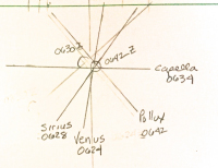
The basic principle is simple. Through astronomical observations, we know very accurately the positions of the stars, sun, moon and planets at any time. We can project the location of a particular object onto the surface of the Earth at any particular moment, known as the Geographic Position (GP). If we are at that exact position, that object would be directly overhead (that is, at an altitude of 90 degrees). If we are away from that point, the altitude will be lower, and we can use the observed altitude (measured with the sextant) to compute our distance from that GP. If we plotted the GP on a globe, and drew a circle around it with radius equal to that distance, we would be somewhere on that circle.

In practice, since we have some idea where we are in the world, we only need to draw the part of that circle that passes near our assumed location, which is a “line of position” (LOP). If we do this with three or more objects, we get several lines, all of which should pass through our position, and when we plot them, we get a position fix. Of course, there are lots of details to correct for, and the computation itself is a bit arcane, and time consuming.

Well, we found Tarawa last expedition, and heady with success, we decided to try our hand at some star fixes out here. The results were pretty good as we got an excellent fourstar fix that compared beautifully with GPS. However, it took us about 3 hours of ciphering and most of an eraser to puzzle out the answer. We’ll give ourselves a B+.

OPERATIONS SUMMARY:

Vehicle Mission 06 has REMUS on deck at 0500 for a routine turnaround service. Deck teams will be busy in the morning. REMUS will start mission 07 late in the morning. SEA School and the Daily Progress Report will be held in the afternoon.

View Full Article

Meridian Passages, Volume XIII, Number 12

Central Pacific Edition


WANTED: Wet or Dry

The Floating Dock that Eluded Capture in the Pacific for 6 Years

On March 11, 2011, an earthquake in Japan registering 9.0 on the Richter Scale shook the world. A tsunami event was generated sending walls of water over jetties and levees into seaside towns and villages along the Japanese coast. The toll of death and destruction was devastating. Officially over 15,893 persons killed, 6,152 injured and 2,567 missing. Property losses were enormous . The Japanese Ministry of Environment estimated that 4.8 million tons of tsunami debris washed into the North Pacific; 68 percent sank and 32 percent remained adrift.

The city of Misawa Japan lost four sections of its steel floating dock each 60 feet in length. Three of these sections were later found in 2012 on the shores of Hawaii, Washington and Oregon. There is one that remains undetected. It is suspected to be in the Central Pacific region in an area near the Republic of Marshall Islands. You’re right if that’s where you think we’re going next. If it is found, researchers want to tag it to that it can be tracked and eventually captured for scientific study. Alan Eustace, who will be joining us in a few days, will be bringing satellite tracking devices for this purpose. So if we encounter this runaway, we are equipped to tag it and bag it.

floaing-dockResearchers have already found about 70 species of seaweeds and 240 species of invertebrates and microorganisms living on debris, primarily along Washington and Oregon where most of the work is concentrated. Some of the species are known only from Asia, especially Japan; some naturally occur on both sides of the Pacific; some were previously introduced to North America; some are non-native to Japan; others require more study. Scientists appreciate that even one invader has the potential to cause serious environmental and economic harm. Yet history also shows that most exotics coexist with native species without becoming pests, at least in the short term. Identifying potential insurgents is the daunting challenge, given the continent’s vast, corrugated coastline and the certainty of more debris yet to come.

What is Meridian Passages?

For our search expeditions, Spence suggested that we have a daily ship’s “newspaper,” seeing it as a good way to promulgate details of the ship’s schedule (the Plan of the Day). We saw it as a fun way to get people on the ship involved with each other, to help document the experience, and provide some working material for the Education Team. Thus was born Meridian Passages, Central Pacific Edition.

Passages was a newsletter we had been publishing at Nauticos since 1997, starting back when our company operated under the name Meridian Sciences, Inc. I coined the title Meridian Passages as sort of a triple pun. Our company name was Meridian; a passage is a story, and a meridian passage is the passing of a heavenly body (like the sun, moon, or a star) across one’s meridian of longitude. Hence, the meridian passage of the sun is another name for “noon,” and it is the moment when a body is highest in the sky. The astronomical reference appealed to me, as an amateur astronomer operating a company whose specialties included the science of navigation.

So, the first edition of Volume XIII of Meridian Passages was issued on the day after we got under way. It features news of the day, the official Plan of the Day, a Spotlight on a crew member, a story or article, and a mock “Classifieds” section for fun.

Anyone can contribute, but we rely heavily on Reporter Marika for interviews, Teacher Sallie for SEA School, Photographer Sue for images, Spence for Plan of the Day, Joe for sea stories, and Bethany for layout. They and others have contributed articles and ideas for Classifieds. Of course, whatever happens out here is raw material.

Our first issue was received with raised eyebrows and puzzled looks. But after a few days, folks would come looking if we didn’t roll the presses by our self-imposed deadline.

— Editor.

View Full Article